
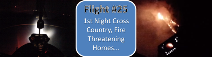
This is the twenty fifth training flight in a series following a student through his flight training from day 1 to checkride in an R22.
This first the student’s first night flight and we make it a cross country to add to the experience. There is a lot to learn in a flight like this and then we discovered fire threatening homes… Some highlights of this lesson:
- Night flying illusions
- Night flying route considerations
- Use of visual glide slope indicators at night
- Discovery of a fire threatening homes and calling 911 while airborne
- Other night flying tips
Below the video are time-stamped notes/tips for the flight.
NOTES/TIPS:
01:00 use taxiways and stay on center lines to avoid hidden obstacles at night
02:00 hover a bit higher due to reduced depth perception and illusions
02:40 don’t forget to properly clear both directions before taking a runway, even at night
03:50 difference between stop and go versus touch and go
04:10 good habit to only takeoff and land on runways (not taxiways) at night due to the guaranteed clearance of runways
06:40 pilot controlled lighting
07:00 verify correct runway using compass
07:15 try not to stare at the spotlight on the ground – look down the runway
07:35 stay aligned with runway centerline until at safe altitude (500′ AGL)
08:30 gauge check before leaving pattern
08:40 discussion on engine failure at night – fly higher than normal and aim for well lit areas
10:05 turn cockpit lighting down as eyes adjust to the darkness to have better night vision outside the cockpit
11:05 open VFR flight plan with McMinnville Radio (FSS)
14:40 check actual needle positions of temperatures and pressures once in cruise to identify any trends
15:55 the hazards of flying over unlit areas at night -even with a full moon and clear skies you can have problems identifying terrain and horizon
17:15 fly high and over the roads to help avoid unseen terrain
17:35 takes 30 minutes for eyes to adapt to night
18:20 plan night cross country altitudes using highest terrain in the area (maximum elevation figure – MEF on sectional charts)
18:45 turn on landing light when approaching airports or other traffic to help find each other
19:35 looking for airport beacon at night (green and white)
20:10 activating pilot controlled lights
20:20 stay high (at least pattern attitude) until aligned with runway and then use PAPI/VASI if they have one (good to brief airport in advance)
22:40 aim to land further down runway to keep best clearance in case of too low approach due to illusions etc
23:05 try to put a distance to ‘extended’ calls – 3 mile extended final
25:00 make the approach slow and to a slightly higher hover at night and try not to focus on the landing light
25:35 ‘closed traffic’ means staying in the pattern
26:15 climb to at least traffic pattern altitude while still over the ‘safe’ runway before turning into darkness
28:40 above 60-70 kts the vertical stabilizer will keep the aircraft mostly in trim if you step off the pedals
31:00 getting VFR flight following (traffic advisories) from Seattle Center
31:10 you can ask FSS like McMennville Radio for radio frequencies
36:20 traffic alert – ideal phraseology is “negative contact” rather than “looking for traffic”
37:30 monitor temperature and dew point spread to predict fog forming on clear nights over the high desert
40:00 once on with ATC (center, approach, tower etc) don’t change frequency (with some exceptions) without request/notify
42:10 how does airspace change when a tower closes? E or G
44:00 at night it is easy to accidentally knock a radio volume knob as you reach down in the dark to do something else
49:20 requesting temporary frequency change
50:45 head to ‘safe’ area of airport rather than cutting corners over unlit terrain
52:35 adjust pilot controlled lighting to lowest intensity when on final (3 clicks)
1:01:30 jump in video to nearer Madras (to save camera battery)
1:06:50 pilot controlled lighting should stay on 15 minutes
1:08:15 reading a VASI white over white, etc
1:11:45 taxiway hold lines
1:13:20 startup at Madras after stopping for fuel
1:14:10 tailwind takeoff – experience the symptoms
1:18:13 jump in video to nearer Redmond (to save camera battery)
1:18:30 VFR traffic advisories
1:29:25 MALSR – medium intensity approach lighting system with runway alignment indicator lights
1:32:00 find a road to follow over unlit areas
1:36:40 have runways numbers of intended destinations on kneeboard
1:37:30 again, don’t be tempted to fly direct to an airport once sighted at night, consider what is between you
1:40:50 memorize pre-landing checklist
1:42:45 PAPI gives protection out to 4 miles within 10 degrees of centerline on glide slope
1:52:00 checking back in with the lovely sounding controller at Seattle Center for ft traffic advisories
1:53:30 jump in video to nearer Bend (to save camera battery)
2:00:20 full moon may be below the horizon
2:00:40 student spots fire next to houses
2:08:40 911 on cell phone to local dispatch is best way to get all the info passed on directly. But if unable to use phone through headset, contact ATC to report the fire
2:11:20 get as much night time, especially cross country night as you can. – some jobs require 100 and some as high as 250 night hours – and it is very hard to get outside of the flight school
To view all the videos in this series, check out this YouTube playlist of all the Flight Training Sessions (Full-Length Unedited)

One Comment on “Day 25 – Helicopter Training Flight #25 – 1st Night Cross Country, Fire Threatening Homes & More…”